
Loma Campana · Añelo · Neuquén — RP 17 and By Pass
The operational heart of the basin
Where the hub sits, what surrounds it, and why that location is the project's core asset.
- 1,000 m
- To the new roundabout
- 7 km
- To Añelo
- < 3 km
- Aerodrome and railway
- < 15 km
- To the key blocks
- 850 m
- Of frontage on RP 17
- +1,000 ha
- TBSA Energy District
RP 17 × By Pass
The basin's service town
Loma Campana · Norpatagónico
≈50% of production
Potential: +2 km
The macro-project framing the hub
In oilfield logistics, distance to the wellsite is not a convenience: it is the business. A supplier's competitive edge is measured by the ability to supply the field in hours rather than days, and that is determined by where its base sits.
Loma Campana is the engine of Vaca Muerta. The site has direct frontage on Provincial Route 17 and is less than 1,000 metres from the new By Pass roundabout, the axis reshaping traffic across the whole basin, with direct access to Neuquén and Rincón de los Sauces.
Directly opposite are YPF's Unconventional Regional Management office and its Crude Treatment Plant. Around them, the bases of YPF Directo, AESA and YPF's Sand Plant. It is an environment with continuous vehicle flow, every day of the year.
The map, point by point
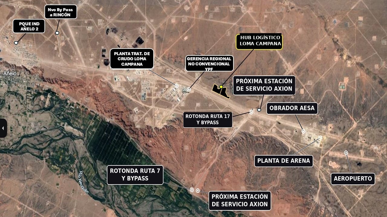
The site is outlined in yellow. The labels on the image are the ones detailed below.
Open in Google MapsWhat is around
YPF Unconventional Regional Management
Opposite the siteOperations
The decision centre for YPF's unconventional operation, on the same RP 17 alignment.
Loma Campana Crude Treatment Plant
Opposite the siteOperations
YPF facility for treating the area's crude.
YPF Directo and AESA bases
Operations
Yards and operating bases that sustain the area's daily movement.
YPF Sand Plant
Operations
Frac sand supply, one of the basin's most intense logistics flows.
RP 17 × new By Pass roundabout
1,000 mAccess
The basin's new circulation axis, with direct access to Neuquén and Rincón de los Sauces.
Future service station and Truck Center
1,000 mServices
On the RP 17 and By Pass roundabout. Earthworks have already begun.
Loma Campana aerodrome
< 3 kmAccess
Air connection for the movement of technical and management staff.
Head of the Norpatagónico railway
< 3 kmAccess
Railhead for bringing heavy freight into the basin.
Añelo
7 kmUrban centre
The basin's service town, with its workforce, retail and suppliers. The site is not within its urban boundary: it sits in Loma Campana, and that difference is what simplifies conveyancing.
The blocks it serves
Within a radius of less than 50 km, the hub serves the blocks that today concentrate close to 50% of Vaca Muerta's production. The most active ones are less than 15 km away.
- Loma Campana
- Angostura Sur
- La Amarga Chica
- Bandurria Sur
- Bajada del Palo Oeste
Access and connectivity
- 850 metres of frontage on the paved Provincial Route 17, with the potential to exceed 2 km on the same alignment as the hub grows.
- 1,000 metres from the new By Pass roundabout, which reorganises heavy traffic across the basin and avoids passing through Añelo.
- Direct access to Neuquén city and to Rincón de los Sauces along the same corridor.
- Aerodrome and railhead less than 3 km away, for staff and for freight that does not come by truck.
The TBSA Energy District
The hub sits inside the TBSA Energy District, a macro-project of more than 1,000 hectares driven by the trust that owns the land.
That institutional framework does two things: it leverages the hub's growth, because the district concentrates the operations that generate the demand; and it reinforces title security, because the land is transferred directly from the owner and developer trust.
This is the site's competitive edge: Añelo falls under its own municipal authority, and what lies outside the urban boundary is Loma Campana. Being on the outside, conveyancing follows a provincial administrative scheme that simplifies the transfer of title.
On-site services and infrastructure
48 m
Central avenue
Dual 15 m carriageways, tree-lined boulevard and pavements. Sized for heavy equipment turning.
2 × 15 m
Cross streets
They front the lots and organise circulation inside the park.
50 + 30
Parking
50 spaces for light vehicles and 30 truck bays, at the entrance.
Water available
Already on site. The rest of the utilities infrastructure is rolled out progressively according to user requirements.
Perimeter and access
Defined perimeter. Gatehouse, access control and entrance identity in design.
Reserved common areas
The master plan reserves land for common infrastructure and for shared schemes between users that create economies of scale.
The two parcels
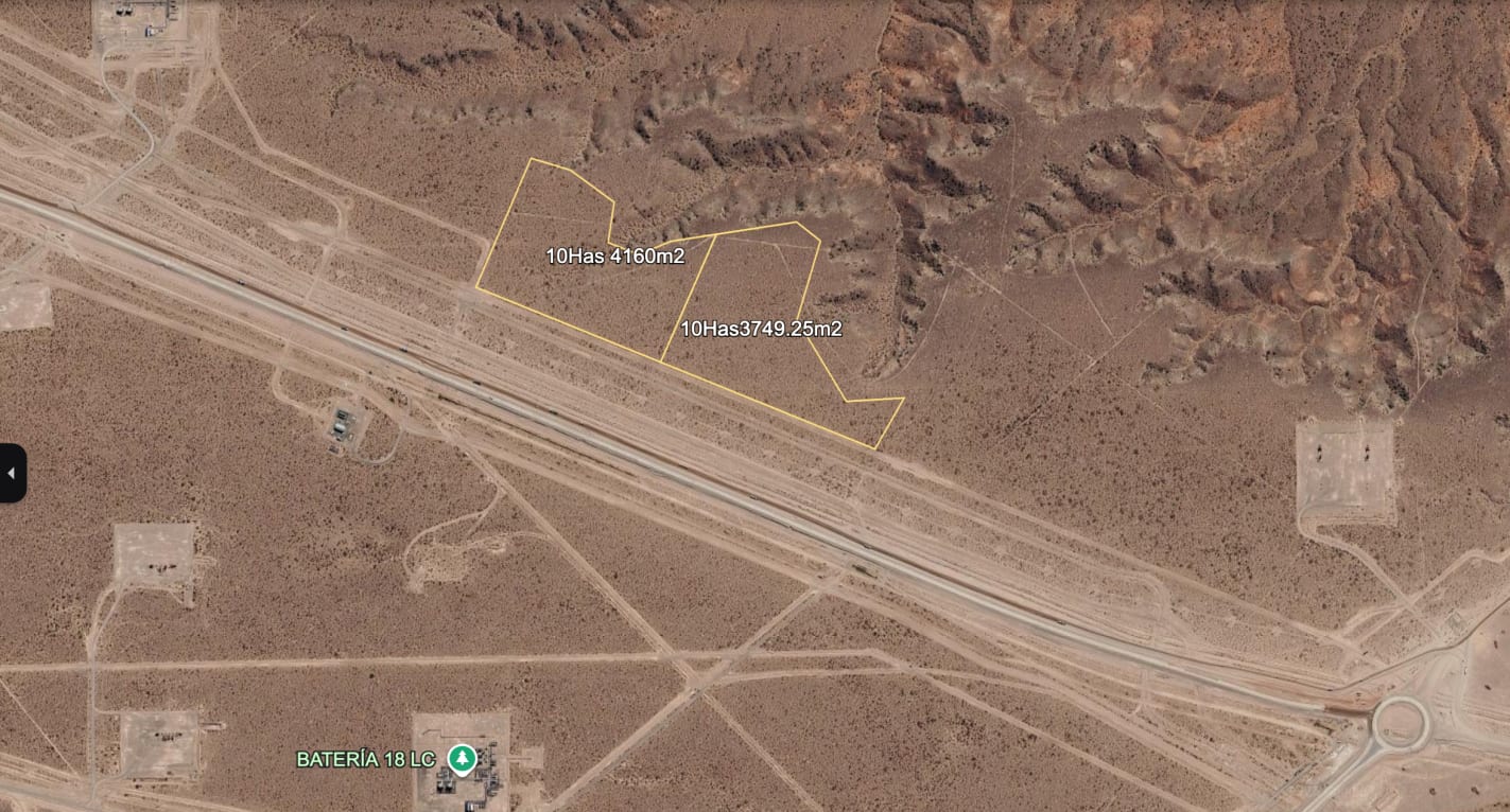
The site totals 20.79 hectares: two parcels integrated into a single master plan.
Request the investment deck
Phase 1 is sold by order of reservation. Request the list of available lots, the survey plan and the current terms proposal.